![]() 1807-1907,
Clare Co.,
1807-1907,
Clare Co.,
General
Land Office Records
![]() Michigan
General Land Office Records
Michigan
General Land Office Records
1807-1907
![]() 1895 Clare Atlas
1895 Clare Atlas![]()
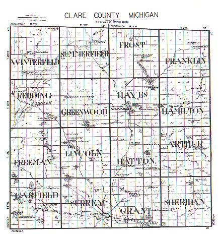
![]() Township Map of Clare County (current)
Township Map of Clare County (current)
![]() Michigan Plat Map Images
Michigan Plat Map Images
The township plat maps are scanned in images of the the actual plats. Names of owners and acreage are indicated. Depending on your browser's capabilities, if you click your right mouse button you may be able to enlarge the map to better view the names. Plot owners are also listed by section for the years indicated. Township maps and Patrons' Lists are from original renderings.
![]() 1807-1907,
Clare Co.,
1807-1907,
Clare Co.,
General
Land Office Records
![]() Michigan
General Land Office Records
Michigan
General Land Office Records
1807-1907
![]() 1895 Clare Atlas
1895 Clare Atlas![]()
![]() Township Map of Clare County (current)
Township Map of Clare County (current)
![]() Michigan Plat Map Images
Michigan Plat Map Images
The State of Michigan began maintaining a file of all plats in
the state in 1873. A copy of all plats prepared after that date were filed
with the State. Beginning in 1909 and completed in 1911, a copy of all
plats on file with the 83 county Register of Deeds and recorded prior to
1873 were duplicated and the duplicate copies incorporated into the
State's files. This system includes all plats in the State of Michigan
beginning with the plats created under the 1821 territorial act for
recording town plats.
The related documents include court orders, municipal resolutions,
municipal ordinances, surveyor's affidavits, and county road commission's
resolutions. Generally these documents alter a plat on file in some way.
There are currently over 66,000 plats on file and images for over 99% of
those plats are available here. Related documents with available digital
imagery are automatically accessed with the plat as additional page (s).
Not all related documents are available in digital form. Additional
related documents might exist that affect a plat and may be available at
the county Register of Deeds.
The system provides print capability of the digital images and related
documents..
Clare
County
Statewide Search
This is the state wide search for subdivision plats from the Department
of Labor and Economic Growth.
Michigan, Territorial Period, 456k.
Map from an 1835 atlas, published in Boston by Thomas Bradford.
Michigan, 1870, Showing Railroad Lines, 546k.
From History and Directory of Kent County, Michigan, Containing a History of Each Township and the City of Grand Rapids, Compiled and Published by Dillenback & Leavitt, County History, Directory and Map Publishers, Grand Rapids: Daily Eagle Steam Printing House, 1870.
1906 Standard Atlas of Clare County, Michigan
including a plat book of the villages, cities and
townships of the county ...
patrons directory, reference business directory and departments devoted to
general information.
University of Michigan Library Site.
Standard atlas of Clare County, Michigan : including a plat
book of the villages, cities and townships of the county ... patrons
directory, reference business directory and departments devoted to general
information / compiled and published by Geo. A. Ogle & Co.
Geo. A. Ogle & Co.
Chicago: Geo. A. Ogle, 1906.
1916 Atlas and Plat Book of Clare County. Michigan
Containing outline map of the county, plats of all the
townships with owners' names,
cities and towns, Michigan state map showing automobile roads, map of the
United States and map of the world.
This is the University of Michigan County Histories and Atlases Collection
Online
1930 Plat Maps
© 2007 - 2020 Donna
Hoff-Grambau
All Rights Reserved

Volunteers hold copyright to the material they have donated for this site. Not to be copied and used in any format to any other site or in any other media.
This server space is provided by
Michigan Family History Network
Visit the Michigan Family History
Network for more Clare County names.
Back to the Clare County Page!