Maps, Plats and Land Records of Bay County

and the State of Michigan

Land Record

  1807-1907, Bay Co.,
General Land Office Records

 Michigan General Land Office Records
1807-1907

 1914 County Map

Township Map of Bay County (current)

Michigan Plat Map Images              

 The State of Michigan began maintaining a file of all plats in the state in 1873. A copy of all plats prepared after that date were filed with the State. Beginning in 1909 and completed in 1911, a copy of all plats on file with the 83 county Register of Deeds and recorded prior to 1873 were duplicated and the duplicate copies incorporated into the State's files. This system includes all plats in the State of Michigan beginning with the plats created under the 1821 territorial act for recording town plats.
The related documents include court orders, municipal resolutions, municipal ordinances, surveyor's affidavits, and county road commission's resolutions. Generally these documents alter a plat on file in some way.
There are currently over 66,000 plats on file and images for over 99% of those plats are available here. Related documents with available digital imagery are automatically accessed with the plat as additional page(s). Not all related documents are available in digital form. Additional related documents might exist that affect a plat and may be available at the county Register of Deeds.
The system provides print capability of the digital images and related documents..

Bay County
Statewide Search

Bay County Township Plat Maps

1916

1930

1884 Bay County Railroad Map


Click on the thumbnail with your mouse to enlarge.

1896 City of Bay City Plat Map

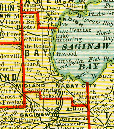
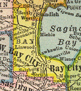
Hammond's 8x11 Map of Michigan, Bay County
Copyright 1904, by C.S. Hammond & Co., N.Y.


Michigan State Maps

Michigan, Territorial Period,456k.Map from an 1835 atlas, published in Boston by Thomas Bradford.

Michigan, 1870, Showing Railroad Lines, 546k.
From History and Directory of Kent County, Michigan, Containing a History of Each Township and the City of Grand Rapids, Compiled and Published by Dillenback & Leavitt, County History, Directory and Map Publishers, Grand Rapids: Daily Eagle Steam Printing House, 1870.


 © Copyright 2003 - 2020
  Donna Hoff-Grambau


ALL RIGHTS RESERVED

  .  
Volunteers hold copyright to the material they have donated for this site.  The material on this site is not to be copied and used in any format to any other site or in any other media. 


This server space page is provided by Michigan Family History Network genealogical server.